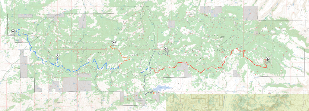
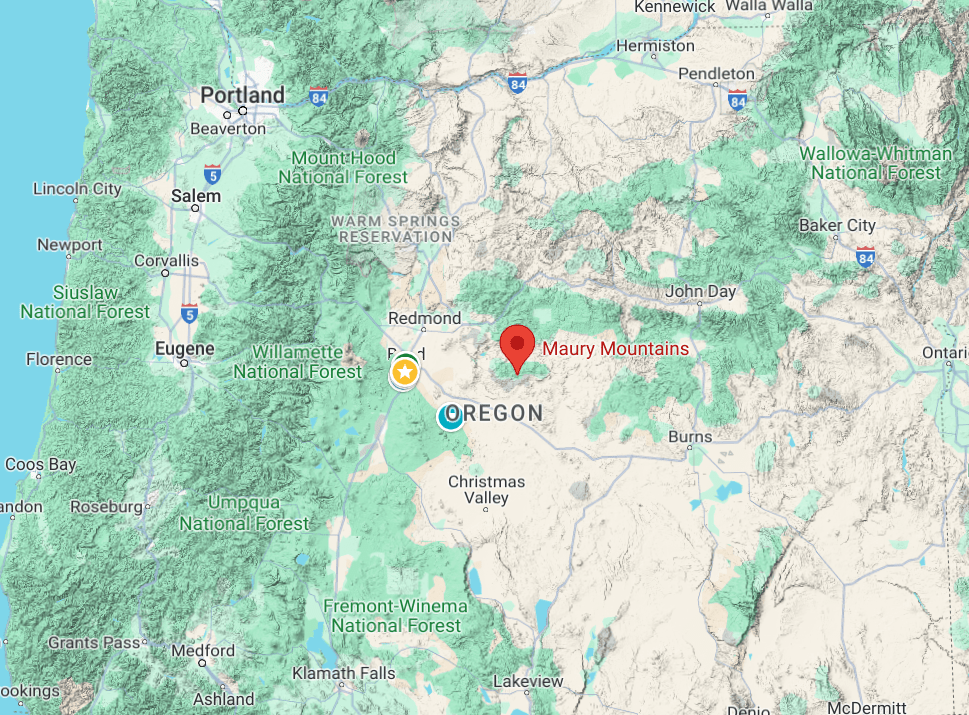
The Maury Mountains are a mountain range in Crook County, OR. Much of the range is within the Ochoco National Forest1. Located Approximately 50 miles East of Bend, OR. There are 5 SOTA Summits within the bounds of the Maury, 3 6 pointers and 2 4 pointers. All 5 are nearly, if not complete drive ups, making it possible to hit all 5 in a weekend. There are ample camping opportunities, including the Antelope Flat Reservoir Campground, a Forest Service Campground, with pit toilets and water.
The roads in the Ochoco NF are very good gravel, though some sections can be rough with corrugation. This means that an intrepid activator can reach the summits with a passenger car, however having something with a bit of clearance can help getting up to Drake Butte and the access road to 6057, both of which are very rocky but passable. The alternative is a longer hike in both cases.
The Maury Mountains run East to West with two major forest Service roads, NF16 and NF17 running through the forest. Both can be accessed off of Oregon State Highway 380, Paulina Highway from Prineville. FS16 makes a big loop through the entire forest and returns to the Paulina Highway. FS17 is a direct access to the Antelope Flat Reservoir. The alternative approach is via Bear Creek Road off of OR 27, the Crooked River Highway that runs south between Prineville, OR and US Highway 20.
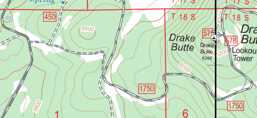
We chose to do the eastern most summits on the first day and the others on the second. We started with Drake Butte, W7O/CE-081. We left the campground and joined up with FS17 northbound. After a quick mile we turned east onto FS 1750, Maury Rd. 1750 starts out in pretty good condition but the surface quickly becomes very large rip-rap gravel, about fist size. It was slow going in the BGNOUT Promaster Van. This continues for roughly a mile, then becomes a very smooth gravel 2 track. We parked at the intersection with 578 while our companion drove on up to the top. The last .1 mile is drivable but there isn’t much space to turn around so I’d recommend parking and hiking the short distance. We worked 2m FM, 20 & 40 SSB on the Yaesu 857D.
Next on the docket we headed west to Mule Deer Ridge, W7O/CE-084. The obvious route is to continue along FS1750, however the first couple of miles are very rutted from folks 4 wheeling through muddy low spots. We almost turned around but things started to improve. For future activators, it might be worth taking FS17 south to FS16 west and up Deer Creek Rd, NF1750-350 to make it a lower stress day. There is a nice meadowy area at the saddle of the road with an old fire pit and ample area to pull off the road. The hike is an easy .25 miles to the activation zone through open forest. The AZ is pretty rocky with not much shade but very nice views to the West and North. We operated on 2M FM, 40M SSB, 20 & 30M CW. We had plenty of 2M action as there was a group attempting to summit Three Finger Jack the same day so there were plenty of chasers on the air.
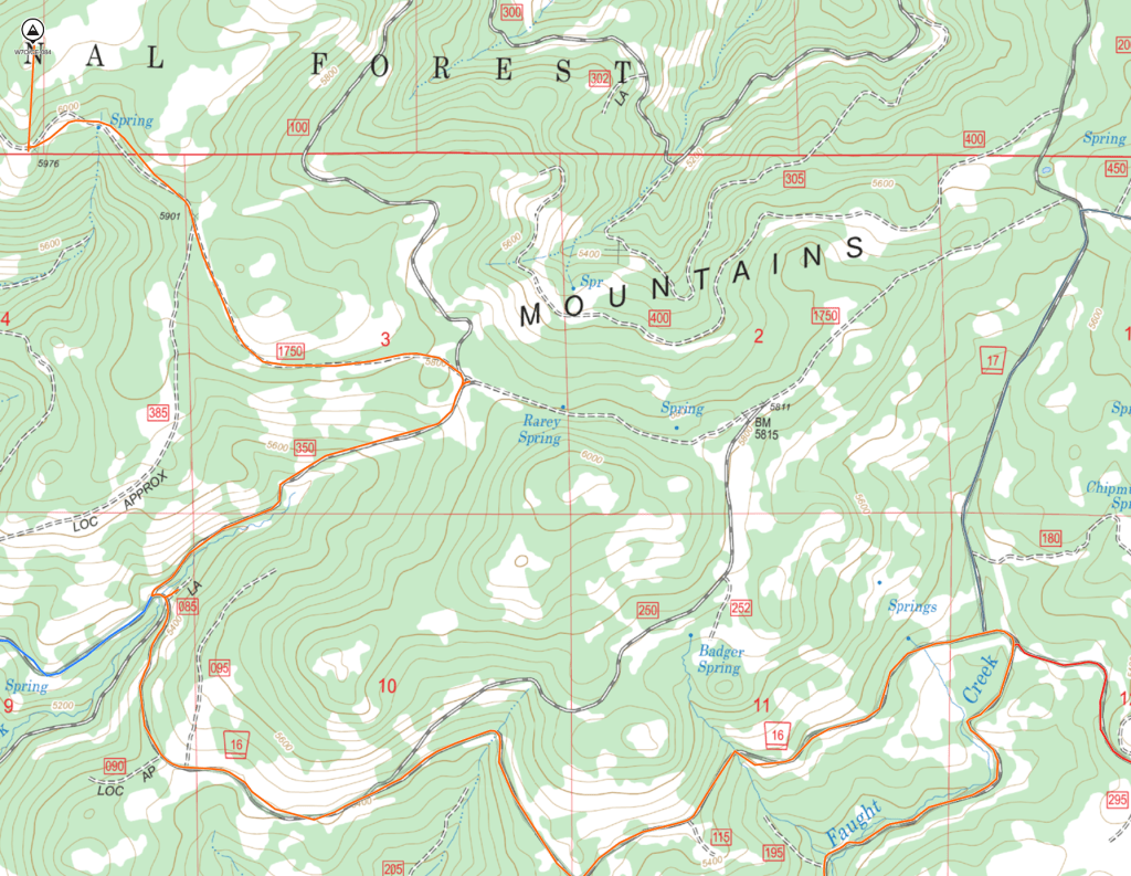
The last summit of the day involved driving to the Eastern most summit, Arrowwood Point, W7O/CE-101. From the intersection of FS17 and FS16 we drove about 11 miles along FS16. There is a lot of washboard and dust. The route then transitions to Arrowwood Loop Road, NFDR1670 to Branch Rd 100 and 101. We parked at the intersection of 101 & 102, and while 102 is a bit overgrown, it is very passable and we could have driven to the top. The road loops around what may have been a lookout tower at some point.
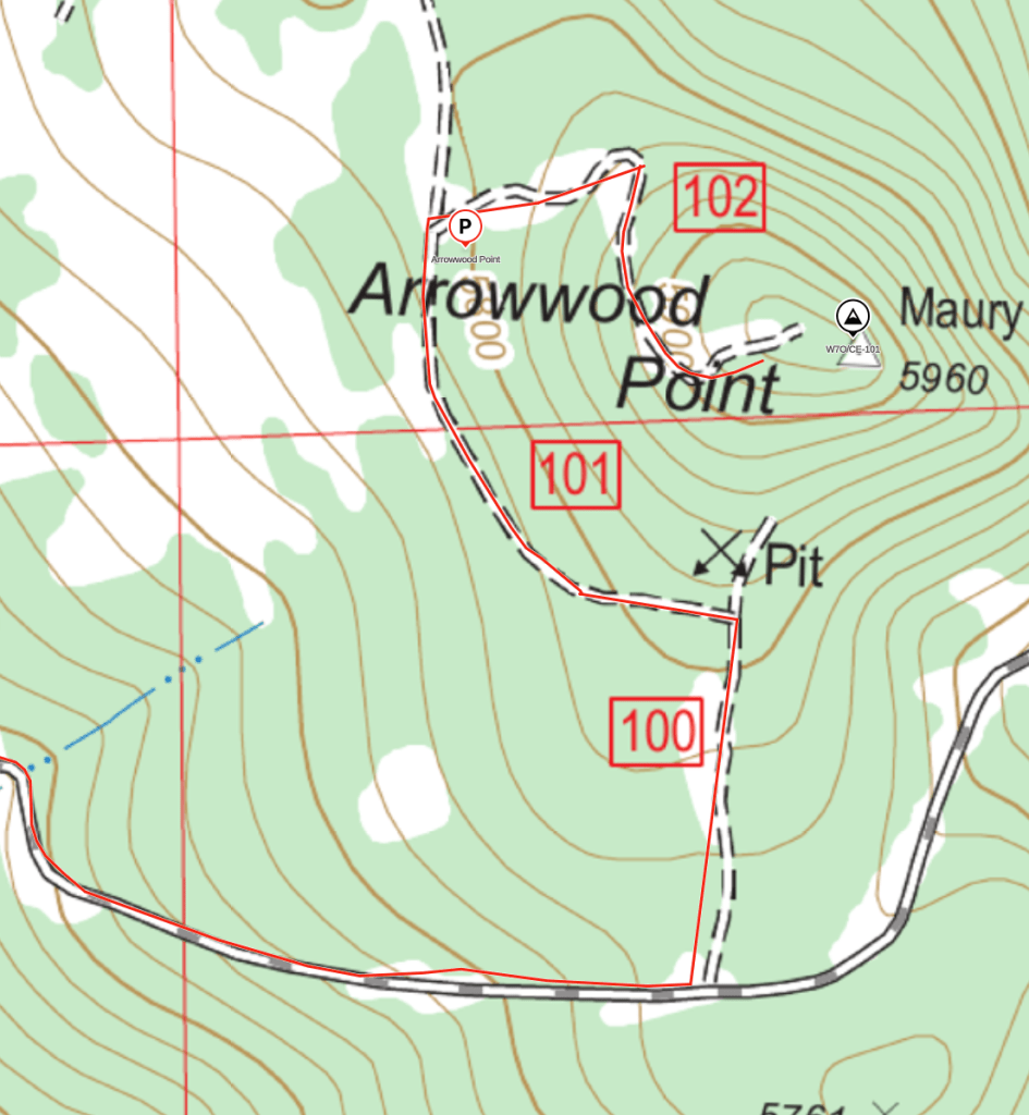
We operated on 17 & 20M CW and 40M SSB. The summit has some pretty cool rock formations but otherwise no views. We made pretty quick work of this summit as we were getting tired and hungry and had to backtrack along the same dusty, washboardy road.
After a very relaxing night at camp, we arose to a gorgeous, sunny morning, coffee and a light breakfast before packing up camp and heading South on FS 16 towards W7O/CE-265, a numbered summit. We continued West on 1750 where FS16 heads North. The 1750-280 is rocky and rough, but passable. We drove the BGNOUT van to within a 1/4 mile of the summit where there is a large open area and parked, then hiked the remaining bit to the top.
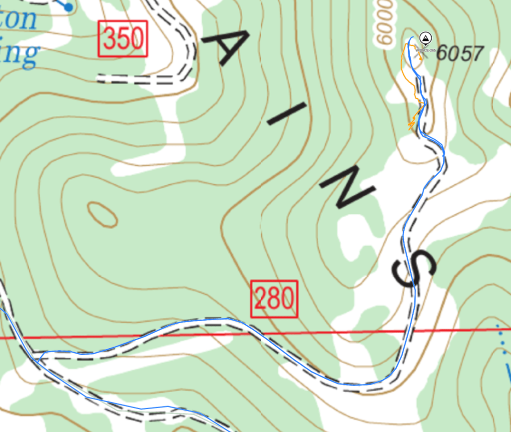
This was by far the best of the weekend with 360 degree views of the Cascades, Ochocos, Paulina Peak and Hampton/Glass Buttes. We worked 2M FM, 20M & 40M SSB and made lots of contacts.
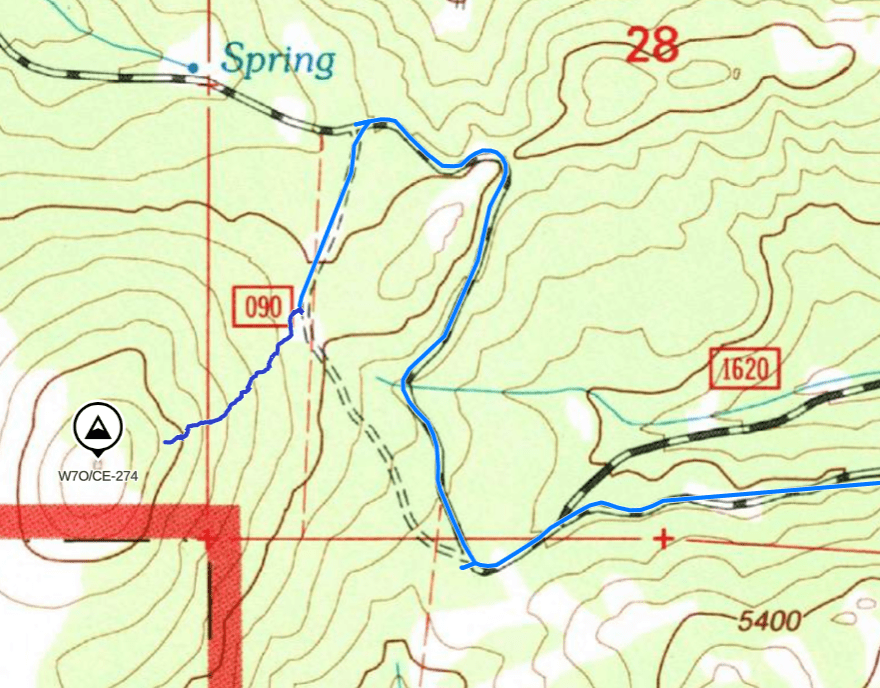
The last summit of the weekend was a short drive along an ever improving NF 1750. Road 90 is a short two track that ends in a meadow where you can park for the short hike up to the summit. W7O/CE-274 is a numbered, 4 point, summit with great views of the Cascades to the West and the remainder of the Maury Mountains to the East. The hike up is short and steep and there are several large juniper trees to provide shade and/or a prop for a wire mast. We made contacts on 2m FM and 40M SSB, including a cross mode contact with KJ7LLS.
The Maury Mountains are a wild and remote section of the Ochoco National Forest located near the geographic center of Oregon. The forest is open and healthy with lots of songbirds and other wildlife. The best time of year to visit is early summer or early fall as it gets hot and dry in the midsummer and the roads are inaccessible with snow and mud in the winter and early spring. The summit hikes are all short and easy. Plan to spend a couple of days in the area off grid as cell service is generally unavailable except on the higher summits.

Leave a comment